

About the Race
The Rebellion Ultra is a 135 mile single-stage race in Mid-Wales. According to the website… “The route is along the full length of Glyndŵr’s Way National Trail with a total ascent of just over 25,000ft (7,700m). The route takes you through some of the most beautiful and remote parts of Mid Wales. Starting in Knighton looping through Machynlleth and then finishing in Welshpool – the route is one of the most picturesque and challenging in the UK.”

The timetable for the event was as below:

Logistics are challenging in Mid-Wales. I decided to drive to the start with my wife and she would then drive back home. I would do the race and take public transport back home.
The race allows each competitor to leave a drop-bag at each checkpoint. The important point to remember is that after the drop-bags have been accessed at the checkpoint they are then moved to the finish, not to the next checkpoint like in some races. So, this means you potentially need more drop-bags and maybe more kit.


My checkpoint strategy was as follows:
- CP 1: Eat & drink. Reload backpack with snacks and water.
- CP 2: Eat & drink. Change kit incl socks and shoes. Recharge GPS watch and phone. Reload backpack with snacks and water.
- CP 3: Eat & drink. Sleep. Eat & drink. Change kit incl socks and shoes. Recharge GPS watch and phone. Reload backpack with snacks and water.
- CP 4: Eat & drink. Maybe sleep. Eat & drink. Change kit incl socks and shoes. Recharge GPS watch and phone. Reload backpack with snacks and water.
Glyndŵr’s Way
There are three National Trails in Wales: Offa’s Dyke Path, the Pembrokeshire Coast Path and Glyndŵr’s Way.
Glyndŵr’s Way came into being in 2000 to mark the beginning of the Millennium and the 600th anniversary of the rebellion in 1400 by Owain Glyndŵr against the English. So that explains the name of the race. Wikipedia has more information about Owain Glyndŵr here.
Glyndŵr’s banner during the 16 year Rebellion known as “Y Ddraig Aur” or “The Golden Dragon” has two legs as opposed to the current Welsh Red Dragon which has four. The footpath signs have a version of this dragon on them.


Check-In
Check-in was a simple process in Knighton. We deposited our various bags with the race organisers and got our race numbers. Then there was a race briefing before we walked across town to the start of the race.


Leg 1 – 23 miles. Knighton to Llanbadarn Fynydd
The start was at 7pm next to the stone pillars marking the start of Glyndŵr’s Way.

As we waited to start, the pedant in me noticed the missing apostrophe on the sign. I don’t think Glyndŵr would be happy loosing his way!
29 of us set off from Knighton into the darkness on the inaugural Rebellion Ultra. It was dry, but cloudy and the forecast was for rain. The first leg to checkpoint 1 was predominantly westward.
We climbed out of Knighton on small roads and footpaths and were soon out on farmland on paths. The footpath was well marked and easy to follow. The terrain was mainly footpaths, quite wet and muddy in places.
Due to the overcast conditions visibility was not particularly great, but we were all making good progress. There were some showers starting.
We were all in good spirits when we arrived at the checkpoint at Llanbadarn Fynydd. It was in the village hall which was a theme for the race. I followed the pre-race plan and did not stop for long, just refilling food and water and getting a few things to eat at the checkpoint.
Leg 2 – 24 miles. Llanbadarn Fynydd to Llanidloes
I think it was just after midnight that we left the village hall and set off on leg 2. Again, generally moving west, but initially going south before looping round to the north as we neared Llanidloes.
The weather was getting worse with constant rain now. There was also some fog. The terrain was similar to Leg 1; mainly rolling countryside and farmland with the occasional bit of road. Navigation was getting harder as it was difficult to see the markers in the fog. It was also apparent that several folks were struggling with navigating at night in general. I would catch them up when they were stationary staring at a map and we would run along a bit, then they would disappear, then I would catch them up again. Folks with proper GPS devices were doing the best in these conditions. My watch was OK and I was using the map as an overview. I did go off course a few times as the Harveys map I had was not quite detailed enough for the terrain and the GPX track I was using did not always agree with the terrain.
I was running with Paul and Sharon at this point and as we were moving up a hill in open fields and I could see the full moon ahead and slightly to the left through a gap in the clouds. Unusual as it had been overcast for a while now and was raining. We noticed that Sharon had stopped and was looking for something in her pack. We decided to go back as it looked like she was trying to change the batteries in her head torch which is always awkward if you are on your own. I then noticed a faint almost vertical line of light that initially looked like a weak laser. Looking at it more closely it became obvious that the vertical line was actually slightly curved before it disappeared into the clouds, so could not be a laser (which was unlikely anyway given the remoteness of where we were).
What we were actually looking at was a Moonbow. I had not even heard of this, let alone seen one before, but it turns out that a Moonbow is actually a thing. I could not distinguish any colours in the Moonbow presumably because it was too faint but the mechanism by which it is produced is the same as for a normal rainbow except the light comes from the moon (although this is reflected sunlight) rather than the sun.
So next time you are out at night and its raining, kept a lookout for moonbows!
If you want to know more about Rainbows and Moonbows click here.
The excitement about the moonbow sighting kept us going for a while. We came to a small village which at this time was deserted. As we were going past a building I could see there was a light on inside. On closer inspection it turned out to be The Glyndwr’s Way Cafe in Bwlch Y Sarnau. A sign welcomed participants in The Rebellion Race to come inside. The village had left it open for us with the heating on and mechanisms to make tee and coffee, etc. and they had left snacks out for us, all with an honesty box. Thank you Glyndwr’s Way Cafe!

We had a coffee and a short rest before continuing on our way.
The temperature had dropped and it was now quite cold, which was a sure sign that the dawn was not too far away. It is always uplifting to see dawn after a long night. I think its a combination of being able to see further and further and distinguish more and more detail as the light levels increase, coupled with a significant rise in temperature.

It was a welcome sight to reach the small town of Llanidloes. The checkpoint was in a community hall. Time for some food and a kit change.
The race team manning all the checkpoints were very helpful, always doing everything we asked and getting us whatever we wanted. The checkpoints were well stocked with both hot and cold food so nobody went hungry.
I did dawdle at this checkpoint and spent about an hour there.
Leg 3 – 28 miles. Llanidloes to Machynlleth
From Llanidloes the route goes north west to Machynlleth. It was mixed weather with sunny spells and showers and we ended up seeing quite a few rainbows along the way.


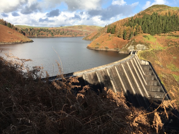
After a few miles we came to a large reservoir, Llyn Clywedog, traversing around the southerly side. This is a man made reservoir built by constructing a dam in 1965-7 to control the flow of water into the River Severn helping to prevent flooding further downstream.
From here we continued north west with the Pumlumons to our west. The route, although continuously undulating, tends to stick to the lower ground and avoids the higher mountains in Wales.
I was beginning to develop some shin pain that I’ve had before in longer races. Also, tiredness had begun to set in so speed had generally decreased and I was walking most of the time now. As dusk began to fall, we were near to Machynlleth.
It took another hour or so to get to the checkpoint. I ate some food and changed kit. I had determined to sleep here. There was a blacked out room for people sleeping so I made my way there. I think I slept there for about 8 hours. It was not the best sleep with people coming in and leaving.
On getting up I had some breakfast and sorted my kit out. It was light when I left. I think in total I was in the checkpoint for nearly 10 hours. Sharon had already left the checkpoint and Paul was saying he was going to retire. He needed to be back at work and did not think he had a chance of finishing and getting to work on time.
So I was on my own again.
Leg 4 – 32 miles. Machynlleth to Llanwddyn (Lake Vyrnwy)
From the checkpoint I hurried back onto Glyndŵr’s Way. Only to discover after a couple of miles that I was heading the wrong way, back the way I had already come! How did that happen? Not paying attention obviously! Also, I had stopped my watch’s GPS tracking at the checkpoint and restarted it on leaving so I had no visual cue as to which direction I had come from. Anyway, after half an hour or so, I was back at the checkpoint!
I had changed into more cushioned Hoka shoes at this point, from the Scott Kinabalus I had been using. Always a trade off between grip with the Scotts on muddy paths and more cushioning with the Hokas.
It had been raining hard overnight but had stopped now. Everywhere was pretty wet and muddy though.


My shin was not feeling too good by this point and I was pretty much walking the whole time now. Also, the Hokas were proving difficult in the slippery conditions, particularly on downhills, which resulted in a few tumbles.
My Fenix 3 HR watch had been going for about 40 hours (with a couple of charges) when I noticed some strange behaviour. The navigation screen would lock up for 10 or 15 seconds (for example turning around would not change the display). None of the buttons would work during this time. After fiddling with it for a bit, I decided to reboot it. This seemed to fix things. This has been the first time I have seen this behaviour with this watch.
Having fixed this, I continued along as normal. I then found a treat wrapped up with a roll my wife had made for me. Small things make a bit difference when you are tired!

A little bit further along, I started getting some heel pain. It felt like something was digging into my heel. Looking at my shoe I could not see or feel anything. With hindsight I should have taken the shoe off and examined it, but I didn’t.
The pain would drift away and then with a particular step would come back with a vengeance! Anyway, I found a way of walking whereby the pain was minimised. It was only after the race when I had got home and was sorting out my kit, that I noticed a piece of hard wood had pierced the sole of my shoe. The Hokas I was wearing have a hard plastic sole which has a gap (for weight reasons) in it. The piece of wood had gone through one of these gaps and pierced the inner cushioning.

It took pretty much all day to get to the last checkpoint and was dark before I arrived. I caught up with Sharon in the few miles before we got there and we plodded in together.
Sharon was going to take a short rest and head out again fairly quickly. I thought I may as well have a longer sleep and crack on in the morning as I was well inside the time limit.
So after arriving at the checkpoint, I got something to eat and went into the darkened room for another sleep. I was carrying a lighter sleeping bag with me but no mat. I put a thicker bag and mat in the bag for the previous checkpoint so this time was a bit more uncomfortable. The lady running the checkpoint lent me her yoga mat to sleep on which was very kind.
Leg 5 – 27 miles. Llanwddyn (Lake Vyrnwy) to Welshpool
I spent about eight and a half hours in the checkpoint so I guess I would have slept for about six and a half. Sharon had moved on so I was on my own again when I set off at dawn in my last set of clean running kit.
It had again been raining overnight but had improved slightly by the morning.
Again the terrain was farmland and undulating hillsides, following the valley of the River Vyrnwy heading east. We went through some small villages; Pontllogel, Dolanaog, Pontrobert and Meifod. From there we climbed up and looped around a small lake.
From there we headed south, and it was somewhere here that I met up with Paul. This was quite a surprise as I thought he had retired at Checkpoint 3. Turns out, he had sorted out his work commitments and decided to carry on. He had arrived after me into Checkpoint 4 and left before me, which is why we did not see each other.
Anyway, we decided to walk in together to the finish.
There seemed to be one last hill by a golf course (good news as we must be getting near to a larger population centre). When we got to the top we could see Welshpool in the distance to the east.
It took a while to plod down into town but we eventually made it. The organisers said that the finish was not at the “official” end of Glyndŵr’s Way but just a few hundred metres from it. Paul and I decided to go visit the official end first, but we were disappointed not to find any official markers there on the bridge.

So we walked back into town and went to the finish.


So out of the 29 starters, 11 finished and Paul and I were joint 9th. According to my watch I had done 146 miles, 11 more than the official distance. I think 4 or 5 of the extra miles were my own fault for coming off the path and the rest were small diversions to the path and inaccuracies in the GPX file due to both rounding and modifications to the trail on the ground not reflected in the GPX (and sometimes not reflected on the map).
Things I Learned
- The cut-offs are quite generous so its possible to finish this with a couple of sleeps, providing you keep moving when out of the checkpoints.
- Its Wales in November so its going to be wet and muddy. I knew this already!
- Take as much kit as you can, its good to change into fresh kit at the checkpoints.
- Although Glyndŵr’s Way is well sign-posted, Navigation at night in the fog can be tricky. Note, the arrows on the signs point, quite accurately, in the direction you need to go, which helps when you can’t see the next sign. A good GPS system accompanied by good map-reading skills are optimal.
- Terrain is undulating and not technically difficult. Glyndŵr’s Way is a strange sort of National Trail. Clearly there have been footpaths here for a long time but stitching them together into Glyndŵr’s Way seems somewhat artificial in the sense that the path doesn’t follow geographical routes like the Pembrokeshire Coast Path or follow political lines, like Offa’s Dyke. Anyway, it is a nice, if somewhat lonely, way to see mid-Wales.
- There are only a few places en-route that have shops where you can buy things. Worth taking some money but don’t rely on this as a means for getting food or drink.
How did the Kit Perform?
- Shoe choice of Scott Kinabalu at the start and Hokas at the end was OK, but probably not ideal. Scotts would have been better for the whole race.
- Injinji mid-level toe socks were fine. I’ve used these many times.
- Waterproofs. Montane Minimus jacket and Montane Trailblazer trousers. Wore the jacket for the whole race and the trousers just once. Both were fine.
- Sealskinz hat and gloves. Worked fine.
- Harveys Glyndŵr’s Way map. Generally fine and gives a good overview. Not quite detailed enough in places to navigate by solely though.
- Garmin Fenix 3 HR watch. I have used this many times and am quite familiar with it. It generally worked well, with one exception. After it had been running for about 40 hrs I noticed the screen started locking up for 10 to 15 seconds (none of the buttons would work). I stopped and saved the activity and restarted the watch and all was fine after that.
- Headtorch Petzl Tikka XP. OK but not as bright as some head torches that were more effective at illuminating the Glyndŵr’s Way signs (which are non-reflective).
- WAA MdS pack. 2 x 750ml bottles were fine. Temperatures and exercise intensities are low so sweat levels are also low so this was enough water. This pack is plenty big enough.
- Unless you’re planning on sleeping outside you will be sleeping indoors so simple sleeping bags and mats are fine. The floors are wood or stone so choose a mat that works for you in this environment.
- Trail food. I took Shot Bloxx, a few energy bars and peanuts. Also, I took a roll and bagel out of each checkpoint with the intention of eating a roll 1/3 of the way to the next checkpoint and the bagel at 2/3 distance.

Pingback: The Spine | John's Running Adventures